World Forest Day, also known as the International Day of Forests, is commemorated on March 21 every year across the globe to spread awareness about the environment.
On this day, the United Nations advises governments all over the world to undertake activities such as plantation drive and wildlife education and promote their forests. The theme for World Forest Day 2020 is ‘Forests and Biodiversity’ in accordance with the objectives of Sustainable Development Goal 15.
Status of Odisha’s Forest Cover
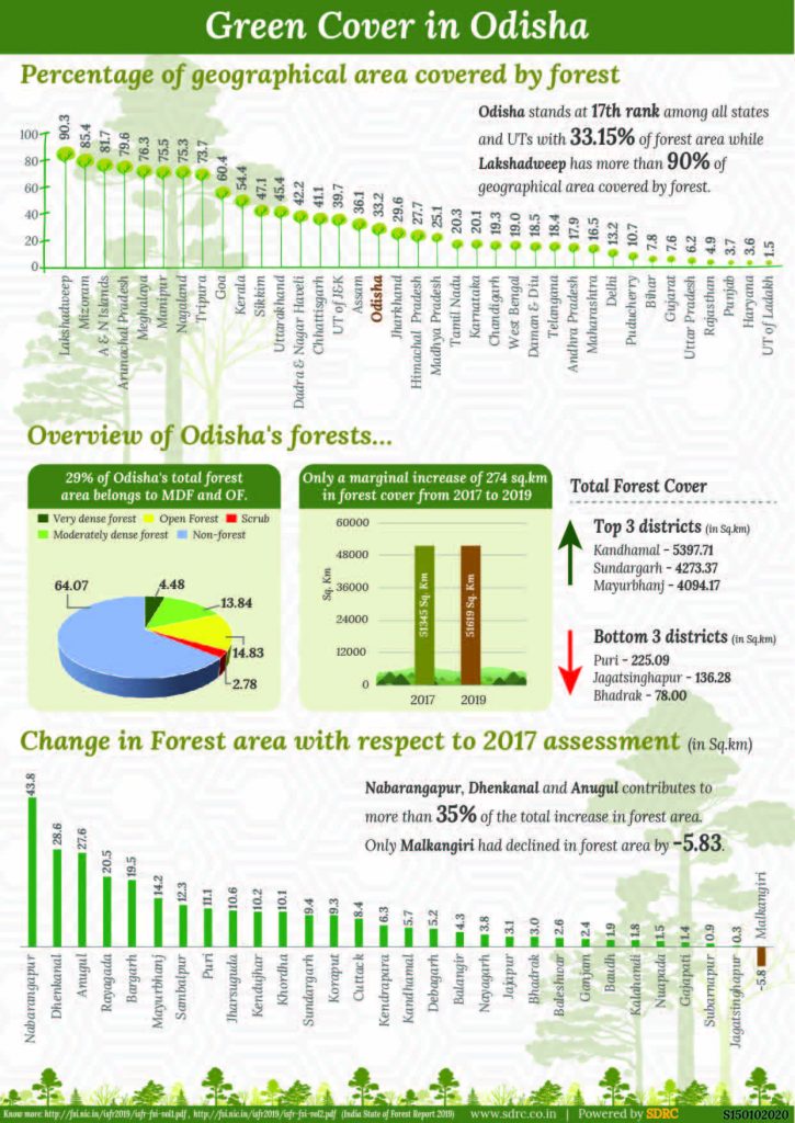
As per the India State of Forest report (ISF) 2019, Odisha’s forest cover has recorded a marginal increase of 274 square km, from 51,345 square km in 2017 to 51,619 square km in 2019.
District wise, Kandhamal has the highest forest cover of 5,397.71 square km that is 65 per cent of its total geographical area. At 4273.37 square km, Sundargarh has the second highest green cover followed by Mayurbhanj at 4094.17 square km.
Boudh and Deogarh also have green cover that is over 50 per cent of their total geographical area.
Bhadrak has the lowest forest cover of 78 square km which is just 1.34 per cent of its total geographical area. Jagatsinghapur and Puri have the second and third lowest green cover at 136.28 square km and 225.09 square km respectively.
Distribution of Odisha’s green cover
The eastern Indian state has 6,970 square km of very dense forest, which is just 4.48% of the total geographical area. It has marginally increased only by three sq km between 2017 and 2019.
At 21,552 square km of moderately dense forest and 23,097 square km of open forest, 29% of the state’s total forest area belongs to moderately dense forest and open forest. While moderately dense forest grew by 182 square km, open forest cover increased by 89 square km from 2017 to 2019.
Scrub is only 2.78% of total geographical area.
Where does Odisha stands compared to other states?
Odisha stands at 17th rank among all states and union territories with 33.15% forest cover.
Lakshadweep ranks 1st with 90.3% green cover.
Mizoram ranks 2nd with 85.4% forest cover.
Andaman and Nicobar Islands ranks 3rd with 81.7% forest area.
Meghalaya ranks 4th with 79.8% forest area.
Manipur ranks 5th with 76.3% forest area.
Nagaland ranks 6th with 75.5% forest area.
Tripura ranks 7th with 73.7% forest area.
Goa ranks 8th with 60.4% forest area.
Kerala ranks 9th with 54.4% forest area.
Sikkim ranks 10th with 47.1% forest area.
Change in forest area with respect to 2017 assessment
Except Malkanigiri, all districts have recorded growth in their forest area. The district has recorded a decline of 5.83 square km of forest cover.
Nabarangpur, Dhenkanal and Angul account for more than 35% of increase in forest area.
Download the Infographic here.


Everybody should need to plant trees, we are alive because of trees only. Everybody should know what are the impacts if we cut trees only instead of planting.
What are the steps government taken to increase forest area?